Showing posts with label "Coast to Coast Trek". Show all posts


Day 5              Patterdale to Bampton Grange


12.2 miles                           Fine but windy


Breakfast was tasty at the White Lion and we stepped out to find the weather wild and windy but with some promising blue patches in the sky.


The White Lion, Patterdale

The Village Stores, Patterdale

The ache under my ankle bone seemed to have moved to the back of my heel and although it felt tight I felt sure I would manage to get to Bampton Grange.

We stopped at the village store to buy fruit and postcards then went along the road before turning to the little hamlet of Rooking, where we saw a quaint cottage with the name 'Wordsworth Cottage', where the famous poet had once lived.


Rooking Village

Wordsworth Cottage

We moved on to the open fell where the climb was gradual, looking down on Brothers Water, but soon became steeper as we headed towards High Street.  Our first point of note was Angle Tarn, looking very pretty when the sun came out and then when we reached Satura Crag we caught our first glimpse of Hayeswater (not to be confused with Haweswater) below to our right.


Climbing Boredale Hause

Looking back to Patterdale

Carole looks very businesslike this morning

High Street was only temporarily our destination and we turned away from it to our clear objective, the climb to Kidsty Pike, the highest point of the Coast to Coast Walk.  On reaching the Pike we found the wind so strong we were wary of getting close to the rocky edge for fear of being made unsteady in the gale.


Our path runs ahead to the top of Kidsty Pike

Passing Stony Rigg

Angle Tarn comes into view

Angle Tarn

Soon after we began our steep descent to Haweswater, the sun feeling warmer as dropped down at a satisfying rate, at first over rocky ground and then onto steep grassy slopes.  The view was stunning, a great expanse of blue water with greenery all around.   As we approached the lake two deer bounded away along the dry stone wall towards a copse.


Starting the climb to Kidsty Pike

Hayeswater (not Haweswater!)

There were several walkers sitting by the lake and we sat nearby an American couple who we would see over the next few days (until our itineraries diverged at Richmond) while enjoying coffee from our flasks.


Haweswater appears below

We reach Kidsty Pike and are nearly blown off!


Approaching the steep descent to Haweswater

We are sheltered from the wind as we descend

The view from the tumble down section of wall where we sat, looking out across the lake, was truly lovely.


'Sometimes I sits and thinks and sometimes I just sits'

A long undulating walk along the lake bankside


We now had an undulating path of nearly 4 miles, following the lake edge which because of its unchanging panorama seemed to take forever.  Finally we reached the dam wall and passed the former dam builders' cottages of Burnbanks before turning away from the Coast to Coast path to follow the road to Bampton Grange and our accommodation for the night, the village store and tea shop and post office.  However, it fulfills all these roles on a part time basis and no-one was at home. Instructions had been left as to how to access our rooms and it was good to relax.  I rubbed cream into my heel, which was now feeling better than when we started out this morning.


The dam wall finally appears in the distance

We join the road to Bampton Grange


Our options for dinner were limited to the village pub, The Crown and Mitre, but we found it had a sign on the door saying 'Closed for World Environment Day.'  We laughed and reported the fact to our host, now returned to the shop.  He told us that the pub was no longer reliable and recently some C2C walkers had only been able to eat crisps for dinner.  We were determined to avoid that fate and with his assistance telephoned the Punchbowl Inn at Askham to book a table, and then arranged a taxi, a service run by a lady who lived over the road. In the end we shared this taxi with three Aussie walkers also staying at the Store and had an excellent meal, although the additional cost had made it an expensive evening.


Day 6     Bampton Grange to Orton


13.8 miles              Torrential rain


We left Bampton Grange to rejoin the Coast to Coast Path near Rosgill.  As we walked along the road we startled a hare which ran off, staying on the road in front of us until it disappeared over a hill in the distance.


Leaving our B&B, Bampton Village Store, Post Office and Tea Room!


Soon we left the road and entered fields, passing the ruined Shap Abbey, with some distance still to walk before reaching the village of Shap.  On arrival we were very pleased to find the Abbey Teashop, somewhat detached from its namesake.  We were dripping wet and muddy and very grateful to the staff for making us welcome.  We ordered large coffees and scones, which we hoped would keep us going until Orton.


Shap Abbey


Back on the road the appalling weather had taken a turn for the worse.  It was like walking inside a wind tunnel while hosepipes were trained on you.  Our waterproofs gave up the ghost and I felt water running on the inside of my leggings.

We turned off the High Street and crossed a footbridge over the Trans-Pennine railway line, then made our way over fields to cross the M6, again by means of a footbridge.  We were blasted by the wind as we crossed the road and were grateful not to be on a Lakeland mountain!

Unfortunately the easterly wind was against us all day, making the long moorland crossing pretty challenging.  I kept my camera as secure as possible in its bag and took very few photographs, disappointed not to be able to photograph the best of the limestone pavements with their almost coral-like structure.  Carole was fascinated by the tiny ferns and plants growing within their crevices.


Our path was a little boggy across Ravenstonedale Moor


A bit of limestone pavement

Carole keeps smiling - just!


Our boots were full of water and it was hard to be cheerful but we came to a fence where a pair of extremely white Y-fronts had been tacked up, bearing the legend C 2 C, which really made us laugh.


A brief sign!

We shelter for a while


Orchids on the moors


After several miles we reached a road, crossed more fields and briefly found ourselves on the B6260 before taking a field track again which led us into Orton.  We passed the chocolate factory and went to the local cafe for a late lunch, then to the pub to book a table for dinner.   In the pub we were delighted to see the Fundraisers.  They were astonished to hear we had come over the top, which they had decided wasn't safe in this weather.  They had walked the whole stage by road.  After swapping horror stories we left them at the pub and our paths never crossed again.


Field paths to Orton


The rain eases as we arrive


The Fundraisers


We found our B&B, Chestnut Garth, where after a bluff welcome (who can blame them?) we were given newspaper to stuff in our boots and the use of an airing cupboard to dry our gear.

As we got ready for dinner I discovered that water had penetrated my supposedly waterproof camera bag and my camera was showing a flickering pink screen when turned on.  I removed batteries and SD card and let it gradually dry out and two days later I was mightily relieved that it was back in working order.


Day 7              Orton to Kirkby Stephen


12.7 miles                Fair and dry


Breakfast at Chestnut Garth was very nice and taken in the conservatory.  Our boots were more or less dry and we were soon on our way.

It was nice to be walking with dry feet, no rain and less in the way of marshy ground.   We began with road walking then joined wide green paths across fields and Ravenstonedale Moor.


House in Orton.  Photos today taken with my phone while my camera recovers

Starting with road walking...

... then into fields

Green paths across fields for much of the day


This was a relatively easy day although our legs were tired from yesterday, but it became a lovely walk when we came to Smardale Bridge where the sun was shining and the views were terrific.

After Ravenstonedale Moor we followed a stone wall for a couple of miles, eventually finding a sheltered spot overlooking Begin Hill where we settled down to our coffee, waving to The Aussies as they passed by. 

We found this grisly head, unsure whether fox or hare


Taken as we sat enjoying our coffee


Moving on, a steep descent took us to a disused railway line, then across Scandal Beck at the picturesque Smardale Bridge.  


We startle the natives

Descending to the disused railway line

Smardale bridge over Scandal Beck


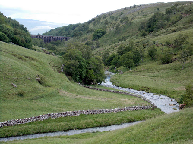
We then walked up onto Smardale Fell where there was an excellent view of Smardale Viaduct in the distance.  The walk from here to Kirkby Stephen was straightforward until we misread a sign at Greenriggs Farm.  Doubling back to correct ourselves we met a man in his 30s, walking fast and heading in the same direction as ourselves.  We walked with him for a few minutes and he told us he was doing the C2C in 10 days, having walked 19 miles from Shap today and arriving with ourselves before 3pm.  He soon left us behind.


Smardale Viaduct in the distance

The weather brightens


We walked in to Kirkby Stephen and found a nice welcome at Fletcher House.  The Aussies arrived shortly after us and we were treated to coffee and cake by our hostess.  Then we wandered up the road to the Black Bull with the Aussies and indulged in a couple of pints.  We booked dinner at the Black Bull for 7 pm but the Aussies said they would stay and eat so they could have a very early night.

We enjoyed our fish dinner at the Black Bull.  Kirkby Stephen was full of members of the travelling community as nearby Appleby Horse Fair was in full swing.  As we ate we watched sukies being driven up the high street and travelers sat outside the pub drinking and talking raucously.  There was a great atmosphere about the place.


The forecast was dire for tomorrow with more heavy rain and wind which made us worry about crossing the Pennines by the Nine Standards route which is notorious for bad visibility and boggy ground.  We mentioned this to our host and she told us that paving had been laid over the worst area of the bog aided by a crowd funding scheme, and this had been recently opened.  We cheered up at this, perhaps we would take the Red Route over the top after all!